|
Berlin, Part 2
Site of Hitler's Death and
Burial, and other area sites

|

|
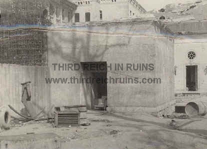
With the Soviet Army
closing in, Hitler reportedly committed suicide in his bunker below the garden of the Reichs
Chancellery on 30 April 1945. This view shows the emergency exit to the bunker (the low
square concrete block, left of center), outside the entrance of which the bodies of Hitler
and his wife Eva Braun were reportedly cremated and buried. The conical tower was an armored
ventilation and guard tower. The F³hrerbunker was underground, in the area behind
and beneath the
emergency exit and the conical tower. The earlier Vorbunker was beneath the
rear of
the Old Chancellery, the low white building in the right rear. (Bundesarchiv
Berlin) The area of the Reichskanzlei has
been completely changed. It was in East Berlin, and the Communist government razed the
ruins and leveled the area, which was near the Berlin Wall. However, the bunkers remained
underground. But in 1988-89, apartment buildings were built on the site of the Chancellery
and along Wilhelmstra▀e, and the bunkers were destroyed in the process. The roof of the
F³hrerbunker, which was reinforced concrete some 10 feet thick, was broken up and allowed
to fall down into the rooms below, and the remains recovered. These remains are now under
a parking lot near the angle in the 1988 street named An der Kolonnade, which runs between
Wilhelmstra▀e and Voss-Stra▀e. (This view is looking toward the apartment buildings
along Wilhelmstra▀e from the end of In der Ministergõrten Stra▀e, approximately the
same angle as the period view to the left. The bunker remains are beneath the parking area
at the right side of the photo, beneath and beyond where the tour group is
standing, and the emergency exit was a little to the left of the center of
the street intersection.) |
Previously unpublished photo of the
F³hrerbunker emergency exit, probably taken in 1946.
The Hitler bodies were cremated in the immediate right foreground. (courtesy
James D. Bass, Jr.)
|

|
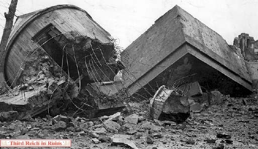
View from the opposite angle,
showing the
collapsed conical tower and emergency exit block,
after demolition by the Soviets in 1947. (AP photo) This
area is now at the intersection of Gertrud-Kolmar-Stra▀e and In der
Ministergõrten.
The emergency exit would have been at the right edge of the modern photo. The Hitler and Goebbels bodies were burned
in the general area where the red minivan is parked, and first buried a
short distance to the right of there. |

|
|
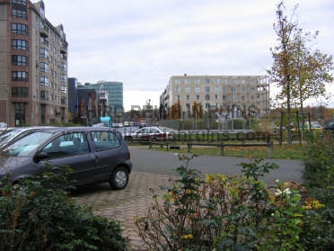
| More modern views of the
site (taken in 2005). The view on the left looks over the bunker site from the west,
toward the Wilhelmstra▀e apartment buildings (see map below). The main part of the bunker
site is between the street in the foreground and the building in the
background. The photo on the right is
a view from the opposite side, looking 180 degrees back. The remains of the F³hrerbunker
are beneath this parking area, street, and grassy area. The street going straight into the distance (toward
Ebertstra▀e) is a recent street called In der Ministergõrten. |

|

|
| These
maps of central Berlin show the
location of the F³hrerbunker site (in red). The map on the left is part of
a 1939 Berlin city atlas (Berliner Morgenpost - "Berlin in der
Tasche") - the F³hrerbunker is shown behind and partly beneath the
old Reichs Chancellery building (the Vorbunker was beneath the reception hall
in the rear of the building). The modern street map on the right shows
this same location, now behind the 1988-89 apartment buildings on
Wilhelmstra▀e (outlined in blue). The site is behind the apartments/businesses at
Wilhelmstra▀e 90-92, beneath a paved parking area and adjacent grassy area. Some guides and web pages say the remains are under a playground,
but that is incorrect - the actual location is farther out from the buildings than the
playground area. The site is at the end of the recent street called In der Ministergõrten
(not shown on this map). (1939 map in author's collection) |
|

|
These comparison
aerial photos from 1945 (left) and 2003 (right) show the F³hrerbunker
site in red. The 1945 photo shows the reception hall of the Old Chancellery
(outlined on the right), beneath which was the Vorbunker, and the
F³hrerbunker site just to the left, with the emergency exit and
ventilation tower outlined at the left edge. |
Click here
for a recent aerial photo of the area, with the F³hrerbunker site marked.
(many thanks to Gary Whelan!)
Click here
to visit a site showing photos of the F³hrerbunker
during its destruction in 1989.
Click here to visit Chuck Anesi's page with
photos of the F³hrerbunker site.
Click here
to visit another page, with then-and-now photos of the Reichskanzlei sites.
Click here
to visit another page with several photos of the Reichskanzlei and F³hrerbunker
sites.
Other links to F³hrerbunker sites
- http://www.hitlerbunker.com/,
http://www.gimmewald.com/europe/bunker.html

|

|
The
Wilhelmstra▀e side of the Reichskanzlei (Reichs Chancellery), seen about
1939 (left) and in 1945 (right). The Reichskanzlei was one of the premier
projects of architect Albert Speer. It was heavily damaged by Allied
bombing and the ruins were destroyed by the Soviets in the late 1940s.
(author's collection) Although
the building itself is gone, some remains can still be seen in Berlin. Red
marble from the interior of the Reichskanzlei was used extensively in the
building of the Mohrenstra▀e U-bahn (subway) station, and also for the
Soviet war memorial in Treptower Park (below). |
 |
 |

Soviet war memorial in Treptower Park,
made of marble from the demolished Reichskanzlei.
(courtesy Robert Newton)

|
|
The Hitler and Goebbels remains
that the Soviets reportedly found in and around the bunker, as well as the body of Gen. Krebs, were
taken to the Berlin suburb of Buch, and autopsied in this pathology clinic on 8 May 1945.
They were then buried in the yard for a short time. The remains were later moved to Finow,
northeast of Berlin, then to a village near Rathenau, west of Berlin. (Note
- this information is based on Soviet records - most German accounts
maintain that the Hitler bodies were burned to unrecognizable fragments.) |
In February 1946 the remains were
again moved, to a Soviet SMERSH facility in Magdeburg in East Germany. The remains were
buried in the courtyards of 32 and 36 Westerndstra▀e, which is now Klausenerstra▀e. They
remained buried there until April 1970, when the KGB had them disinterred and cremated, and
the ashes scattered in the Elbe River nearby. This photo shows the courtyard of 32
Klausenerstra▀e. |
-

|

|
Another
important body found a resting place in Berlin in May 1945, but this one took almost 30
years to come to light. During an attempt to escape the Russian cordon around Berlin,
following Hitler's suicide, Nazi Party Leader Martin Bormann found himself in the midst of
a tank battle at the Weidendamm Bridge, then among Russians (who did not recognize him)
near the Humbolt Hafen. Shortly thereafter, he and his companion SS Dr. Ludwig Stumpfegger
must have decided their escape was hopeless, and they apparently committed suicide by cyanide
poisoning at the side of the Invalidenstra▀e near the Lehrter Stadtbahnhof station (see
left-hand photo above). This was sometime in the early morning hours of May 2, 1945. Their
bodies were seen there later that morning by Reich Youth Leader Artur Axmann.
They were hastily buried nearby in an unmarked grave as unknowns. During
construction in the area of the station arches (right-hand photo above -
the actual site is about 250 meters to the left of this photo location) in
December 1972, two bodies were unearthed. They were identified at the time
by dental records as those of Martin Bormann and (likely) Dr. Stumpfegger.
Due to the persistent rumors that Bormann survived the war, the family
requested DNA tests be done on these remains in 1998, proving that the body
found in Berlin was Martin
Bormann's. (See http://news.bbc.co.uk/1/hi/world/europe/87376.stm
and http://news.bbc.co.uk/1/hi/world/europe/87452.stm) Note:
The Lehrter Stadtbahnhof has been demolished for construction of the new
Berlin Hauptbahnhof (2002-2006), and this site is now no longer recognizable. |
-

|

|
Berlin
was already the location of the burial site of one of most important heroes in the Nazi
pantheon - Horst Wessel. Wessel was the leader of Sturm 5 of the SA (Sturmabteilungen -
Storm Troopers) in a predominately Communist section of Berlin in the late 1920s. In
January 1930 he was shot in his apartment by Communists, dying in February. Propaganda
Minister Joseph Goebbels turned him into a martyr, and Wessel's song "Die Fahne
Hoch" (Raise High the Flag) became the unofficial Nazi Party marching anthem.
(Click here
to see photos of Horst Wessel's birth house in Bielefeld.) (left
- Imre Lazar, "Der Fall Horst Wessel," Stuttgart, 1980; right - Erwin Reitmann,
"Horst Wessel, Leben und Sterben," Berlin, 1933 (author's collection) |

|

|
| After the Nazis came to
power in 1933 they erected an elaborate monument at Horst Wessel's grave in
the Nikolaifriedhof, which was the
scene of yearly ceremonies. Above - Hitler speaks at the grave in January
1933. (above left - Bayerische Hauptstaatarchiv; above
right - Life Magazine, 28 March 1938; below - author's collection) |
 |
 |
 |
Following the end of the war, in common with other Nazi
shrines and graves, Wessel's grave marker was removed (some sources say his body was also
removed). For many years, the marker remaining on the grave had faint
letters on the back for Horst's father Ludwig. However, this marker was
recently turned upright (see upper photos), and research and the
discovery of a 1935 photo showing the back of Horst's cubic marker
(below right) by Steven Stasi shows that the current stone was actually
part of Horst's marker - the face used for his father Ludwig was
actually the back of Ludwig's original marker. Close examination of the
current marker clearly shows the same lettering for Pfarrer Dr. Ludwig
Wessel and the dates, as seen in the 1935 photo, as well as the
attachment points on the edge for the final lettering for Horst's
brother Werner. (upper and lower left - author's photos; others many
thanks to Steven Stasi) (MapQuest
Map Link)
Note -- This grave marker fragment
was removed and the grave site was leveled by cemetery officials in
August 2013. |
 |
 |
 |
 |
| The
photo above shows the crowd at Wessel's grave, likely during the
erection of his Nazi marker in 1933. The mausoleums in the background
can still be seen today, showing quite a bit of damage from the
April-May 1945 battle for Berlin. (This spot is actually some distance
from Wessel's grave, indicating how large the crowd was.) The photo
below shows the same grave shrines in the background that were seen when
looking over the Wessel grave plot and marker. |
 |
 |
|

|
|
World War II in Europe
ended officially on 8 May 1945 in this building in the Berlin suburb of Karlshorst. In the
room seen in the right-hand photo below, at the table in the foreground, Army Chief of Staff
Field Marshall Wilhelm Keitel and other German military leaders signed the unconditional
surrender papers in the presence of leaders of the victorious Allied forces. The building
is now a museum. (above - U.S. Army Signal Corps Collection,
National Archives) |

|

|
more info - www.museum-karlshorst.de
-

|
A grisly reminder of Nazi tyranny
in Berlin is the remains of Gestapo headquarters at No. 8 Prinz Albrecht-Stra▀e,
"the most feared address in the Third Reich." This wall and gate remain at one
end of the courtyard, and prison cells in the excavated basement on the other end are now
used for the "Topography of Terror" exhibit. |

|

|
Another reminder in the area is
the Sachsenhausen Concentration Camp Memorial, a few miles
north of Berlin near Oranianburg. This view of the entrance building shows the iron gate
with its motto "Arbeit Macht Frei,"
or "Work Makes You Free." (left - Bundesarchiv) |
|
|
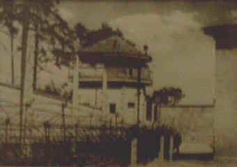
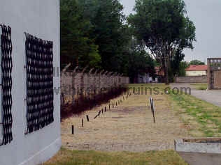
Fence and guard tower at
Sachsenhausen
(Gedenkstõtte Sachsenhausen) |
Similar view today |
Click here
to see a site near Berlin that was part of the Autobahn highway system.
"Topographie des Terrors" Exhibit -- http://www.topographie.de
Other concentration camp sites -- Dachau,
Buchenwald, Dora (Nordhausen), Flossenb³rg, S/III Jonastal, Mauthausen (includes Gusen), Ebensee
(Austria)
Click
here for a MapQuest map link to Berlin.
 Continue
to Part 3, Other Berlin Sites Continue
to Part 3, Other Berlin Sites
 Back to the Third Reich in Ruins homepage
|

