|
Miscellaneous Sites
Associated with the Third Reich
Part 1
The following sites can be found
on this page. Click these links to proceed directly to a particular site. Bad
Berneck (Bavaria), Baldham (Bavaria), Bamberg,
Heidelberg, Kitzingen
(Bavaria), Lambach (Bavaria), Neuschwanstein Castle and Linderhof
Palace (Bavaria), Mangfall
Bridge (Bavaria), Bergen Bridge (Bavaria), Holledau Bridge (Bavaria), Ochsenfurt
(Bavaria), Saint-Marcouf (Normandy, France), London
(England), Stadtilm
(Thüringen), Stuttgart (Baden-Württemberg), Wasserkuppe
(Hessen), Kaiserslautern (Rheinland-Pfalz), Thingplatz
sites, air raid shelter sites. The sites in
Part 2 include the Bavaria-Thuringia border (Luftwaffe radar site),
Doggerwerk, Hirschbachtal, Bayreuth, Kronach, Marktzeuln, Miesbach,
Gallneukirchen, Murnau, and Autobahn ruins (Bavaria), Tondorf
(Nordrhein-Westfalen), Hirschberg and Jena (Thuringia), Michendorf (Berlin), and
Kaiserslautern (Rheinland-Pfalz). The
sites in Part 3 include Eichstätt,
Neustadt bei Coburg, Neustadt an der Aisch, Langenzenn, Kelheim, Vilsbiburg, Coburg, Aschaffenburg, Fladungen, Oberwildflecken, Urfeld, Pleikershof, and
Bayrischzell (all in Bavaria); Rodert/Bad Münstereifel (Nordrhein-Westphalen); and Ziegenberg, Giessen, and Windecken
(Hessen); Freudenstadt (Baden-Württemberg); and Brûly-de-Pesche (Belgium). The
sites in Part 4 include bunker sites and a Nazi
war memorial in Bavaria, air-raid shelter bunkers in Fürth (Bavaria), sites in Goslar, Braunschweig and elsewhere (Lower
Saxony), Nazi Finance School in Herrsching, Nazi Farmers Academy in
Mindelheim, Muggendorf, Hilpoltstein, Grafenwöhr, and Göring's castle (all in Bavaria),
Rheinhotel Dreesen in Bad Godesberg (Nordrhein-Westfalen). The sites in Part
5 include the DAF School at Erwitte (Nordrhein-Westfalen); Amtsgericht, Volksschule,
and Siemens building in Erlangen (Bavaria); Reichsbank in Koblenz (Baden-Württemberg); and
the SS Honor Castle at Wewelsburg (Nordrhein-Westfalen), Luftwaffe test site at
Rechlin (Mecklenburg-Vorpommern), V-2 rocket development site at Peenemünde
(Mecklenburg-Vorpommern), NSKK School at Kochel am See (Bavaria), Rathaus at
Mittenwald (Bavaria), Hitler at Walhalla (Bavaria), SS Lebensborn Home at
Steinhöring (Bavaria), Forsthaus at Lohr am Main (Bavaria). The sites in Part
6 include Frankfurt am Main (Hessen), Feilitzsch (Bavaria), Tannenberg (East Prussia), Ratibor
(Upper Silesia), Sassnitz (Saßnitz) (Mecklenburg-Vorpommern), Stetten am kalten
Markt and Kirchheim unter Teck (Baden-Württemberg). The sites in Part
7 include Wusterhausen an der Dosse (Brandenburg), Lienz (Tyrol, Austria),
Geretsried, Deiningen, Heuberg (Bavaria), Carinhall and Ravensbrück
(Brandenburg), Dinkelsbühl, Rothenburg o.d. Tauber, Ansbach, Lichtenau, Neumarkt i.d.
Oberpfalz (Bavaria); Adolf Hitler Koog (Schleswig-Holstein), Masurian Canal locks (Poland).
The Sites in Part 8 include
Radolfzell am Bodensee and the Haigerloch Atomkeller (Baden-Württemberg), the Bückeberg Reichsthingstätte
and U-Boat Bunkers in Bremen (Lower Saxony), Hermann Monument at the Teutoburger
Wald (Nordrhein-Westfalen), Germersheim (Rheinland-Pfalz); and Augsburg, Augsburg-Biburg,
and Landsberg (Bavaria); and Schönau im Schwarzwald (Baden-Württemberg).
The sites in Part 9 include Erlenbach am Main
(Hessen) and Kaufering (Bavaria).
-

|

|
| The Hotel
Bube in a period postcard view, and the corresponding scene today. |
-
|

|

|
| The
bridge over the Mangfall river valley southeast of Munich was the first long
bridge in Hitler's Autobahn highway system. The Autobahn between Munich
and Salzburg was important to Hitler, as he traveled that route often,
and it passed through the part of Germany he had adopted as his home
(Oberbayern - Upper Bavaria). Hitler took a special interest in the
Mangfallbrücke, which was 330 meters long and 68 meters high. On the
left, Hitler visits the nearly-completed bridge in the summer of 1935.
The bridge was blown in April 1945, but rebuilt (with a third pylon
added to each support, to widen the highway). The Mangfall Bridge is
just west of Exit 98 on Autobahn A8 at Weyarn. It's not very impressive
as you drive over it - it needs to be seen from the valley below to be
appreciated. ("Adolf Hitler - Bilder aus dem Leben des
Führers," Cigaretten-Bilderdienst, 1936) (MapQuest
Map Link) |
 |
 |
 |
|
Building the Mangfall Bridge in 1935. The view on the right is from a
period painting. (left - from Stanley McClatchie, "Sieh: das Herz Europas,"
Berlin, Hoffmann, 1937) |
 |
 |
 |
| In April 1945 the Mangfall Bridge was blown by the retreating German
forces. (left - courtesy Doug Quebbeman; right - photo by Jerry
Pinkowski, courtesy Scott Pinkowski) |
-

|

|
| Another long bridge in the
Bavarian Autobahn system was the nearby bridge over the Bergen valley,
seen on the left in Gerdy Troost's architectural book Das Bauen im
neuen Reich (Vol. 1, 1942 ed.). Note
- This historic bridge was replaced by new construction in 2012.
(MapQuest
Map Link) |

Bergen Bridge in the winter (from
Stanley McClatchie, "Sieh: das Herz Europas," Berlin, Hoffmann, 1937)
-

|

|
| The bridge
over the Holledau valley north of Munich was another long bridge in the
Bavarian Autobahn system. The Holledaubrücke was built 1937-38 under a
design by Georg Gsaenger of 16 arches of Roman viaduct style. The bridge
was partially destroyed in 1945 but later rebuilt. The bridge is located
at the exit for the Rasthaus Holledau, the main building of which was also
built during the Third Reich (just north of the Schweitenkirchen exit on
the Autobahn). (MapQuest
Map Link) |

The Holledau Brücke was also blown by
retreating German forces in 1945 (private collection)

|

|
| The
Rasthaus Holledau is seen on the left from a period color photo. The
building has been modified over the years, but is still an Autobahn rest
stop and restaurant. A sign on the restaurant claims "Hearty Bavarian
Cuisine Since 1938." |
For further sites associated with the
Autobahn highway system, see Part 2.
-

|

|
| Another
of Hitler's favorite inns was the Lambacher Hof, on the north shore of Chiemsee
lake between Gollenshausen and Seebruck. Before the Munich-Salzburg Autobahn
was completed, Hitler often traveled the old road past Chiemsee during his trips between
Munich and the Obersalzberg, allowing a stop at
the Lambacher Hof.
This inn is where Eva Braun's parents first met Hitler in 1933. (period
postcards) (MapQuest
Map Link) |
|

|
 |

|

|
| Hitler
arrives at the Lambacher Hof
during one of his visits. The windows and the Luftmalerei artwork have
changed a little over the years. (period postcard) |

Hitler and his convoy outside the
Lambacher Hof, from a period postcard.

|

|
| The
Lambacher Hof kept a special dining area for Hitler and his entourage, the
"Hitler Stübchen." The interior has been remodeled but remains
a cozy restaurant. (postcard view courtesy John Dobson) |
-
 |
 |
| Although
Hitler disliked the aristocracy and the German royal history, he did visit
at least three of King Ludwig II's Bavarian castles. He is seen here
visiting the famous Neuschwanstein Castle near Füssen. (Heinrich
Hoffmann, "Deutschland Erwache," period postcard; many thanks
to Matthew D. Rector for the modern photos) |
 |
 |

|

|
| Hitler
also visited Schloss Linderhof, seen here at the entrance to the palace, with the corresponding view today (Hitler
was coming out of the left-hand doorway). (Heinrich Hoffmann,
"Hitler in seinen Bergen," Berlin, Hoffmann, 1935) (MapQuest
Map Link) |
 |
Stuttgart
|
|
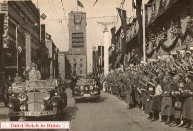
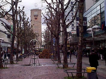
Adolf Hitler visited
Stuttgart in March 1938. His motorcade drove down Königstraße from the Hauptbahnhof.
Trees grow along that route today, and a Mercedes symbol replaces the swastika flag on the
top of the Bahnhof tower. (Heinrich Hoffmann, "Hitler Baut
Grossdeutschland," Berlin, 1938 (author's collection) (MapQuest
Map Link) |

|
|
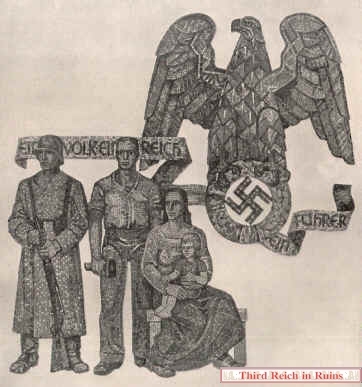
Hitler's entourage
drove through the Hauptplatz (main city square). Stuttgart was heavily bombed during the
war, and a comparison modern photo would show only post-war buildings of a different
style. The main post office featured Nazi mosaics in the grand hall; the building is still
there but the mosaics are gone now. (photo on left from "Hitler Baut
Grossdeutschland;" on the right from "Kunst dem Volk," edited by Heinrich
Hoffmann, Special Edition, Vol. 10, No. 7, July 1939 (author's collection) |
-

|

|
Stuttgart's wartime
buildings included an air-raid shelter of a unique style. These so-called Winkeltürme
(Winkel Towers) were cone-shaped concrete towers designed by Leo Winkel of Duisburg.
Winkel patented his design in 1934 and began construction in 1936. Eventually some 98
Winkeltürme of five different types were built. The towers were intended mainly as
protection for factory workers and railroad personnel, and they appeared most often in
areas of heavy industry and rail centers. This Winkelturm in Stuttgart, a Type 2, is
located on Wiener Platz in the
Feuerbach rail area. The cone shape was designed to defeat bombing attacks by deflecting
bombs off the top and sides, toward a reinforced area around the base. However, a
Winkelturm of this type in Bremen suffered a direct hit by U.S. bomb in October 1944,
which exploded through the roof and killed five people inside. Click here
to see other Winkeltürme in Giessen, and here
in Zossen near Berlin. (see
Michael
Foedrowitz, "Die Luftschutztürme der Bauart Winkel in Deutschland, 1936 bis
Heute," Waffen-Arsenal Band 175, Podzun-Pallas-Verlag, 1998; also http://www.luftschutz-bunker.de/winkel_tuerme.htm)
(Google
Maps link) |
-
 |
 |
These
two Winkeltürme of Type 1c are located on either side of a former Reichsbahn RAW
depot maintenance facility in Kaiserslautern.
(Google
Maps link; the second tower is about 200 meters to the east) |
 |
 |

|

|
The
headquarters building of the former RAW (Reichsbahn Ausbesserungs Werk)
maintenance facility, located on Pariser Straße in Kaiserslautern, still
displays the Reichsbahn insignia of a winged locomotive wheel. (Google
Maps link) |
-
 |
 |
 |
| These
three Winkeltürme are located in Darmstadt. The first two, Type 2cs, are
located north of the city in an industrial area. The Type 1 tower on the
right is located in the Starkenburg Kaserne military area. There is also
a fourth Winkelturm on the Starkenburg Kaserne, not accessible to the
public (and not shown here). (Google
Maps link; the second nearby tower is about 300 meters to the
northwest) |
-
 |
 |
 |
| Three
air raid shelter towers of the Winkel type (Winkeltürme) were
built in Ludwigshafen am Rhein. The tower on the left above, of the Type
2c, is located behind a bowling alley (Google
Maps link,). The other two towers are located in the main rail yard
area (center - Google
Maps link; the tower on the right is 300 meters north). Other air
raid shelter types appear below - The octagonal tower on the left below
was converted to a water tower after the war (Google
Maps link). The air raid shelter bunker on the right below has
period artwork above its entry doorway (Google
Maps link). |
 |
 |
 |
 |
 |
| This is
not a Winkelturm, but a Luftschutzturm of the "Dietel" type, located
in Heilbronn. The period photo on the right shows a tower of the same
design in Rüsselsheim (this tower no longer exists). (photo
courtesy Dominik Stockmann; period photo from Gerd Rühle, ed.,
"Das Dritte Reich," Berlin, 1938 ed.) (Google
Maps link) |
 |
 |
| Luftschutztürme
of the "Dietel" type were named for historical military heroes. This
tower near the main rail yards in Darmstadt was named for World War I
flying hero Manfred von Richthofen (the "Red Baron"). This
tower still exists, with the eagle and name removed, and the roofing
replaced. The flat area at the top of the roof could
be used to mount small Flak guns or searchlights. The Rüsselsheim tower
shown above was named for Oswald Boelcke, another World War I flying
hero, Richthofen's mentor, and the Heilbronn tower above was named for
Walther Wever, an infantry officer. (U.S.
National Archives, RG111SC-352561) (Google
Maps link) |
-
 |
 |
| The
Heilbronn Rathaus (city hall) was decorated with a swastika flag
in 1933. The front, including the famous zodiac clock, remains virtually
unchanged. |
 |
Heidelberg

|

|
The Heiligenberg
(Holy Mountain) overlooking Heidelberg was the site of an unusual Nazi edifice - a
"Thingstätte." In early Nazi quasi-religious Völkisch ceremony and Blut
und Boden (Blood and Soil) ideology, a "Thing" was an open-air gathering of
the people, harking back to old Germanic pagan gatherings. Some 1200 "Thing"
sites were planned, but only about 40 were built, as the Nazi hierarchy lost interest in
the "Thing" movement in 1936. Another such site that remains today is the
Dietrich-Eckart-Bühne adjacent to the Berlin
Olympic Stadium. (1936 postcard in author's collection) (MapQuest
Map Link) Click here to
visit a "Third Reich in Ruins" page showing other Thingplatz/Thingstätte
sites.
Virtual Tour of the Heidelberg
Thingstätte by Benjamin George -- http://gardentaining.com/dililah/thingstatte_map_post.html |

|

|
The views above
show the Heidelberg Thingstätte from the highest point of the site. At
either side of the period view can be seen hexagonal flag towers (obscured
by trees in the modern photo). (postcard courtesy Teresa
Boni) |

|

|
Current
views of the flag towers near the top of the site. The remaining flagpole
appears to be the original. (Note - In June 2008 this flagpole was no
longer there - thanks to Bob Lyons for this information.) |

|
|
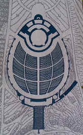
| The wide-angle composite
photo on the left and the plan on the right show how the Thingstätte was built as an
amphitheater. The Heidelberg Thingstätte was begun on 31 May 1934 and opened officially on 22 June 1935 by
Propaganda Minister Joseph Goebbels. Speaking to a crowd of 20,000 people, Goebbels called
the Thingstätte a "veritable church of the Reich." |
|

|

|
| Above - Two
photos from the Heidelberg Thingstätte during its opening ceremony in
June 1935. On the right, the Reichs Arbeitsdienst (Labor Service) at the
"consecration." Below - This period photo taken from the
crowd's perspective may also have been from the opening ceremony. (above
- courtesy Teresa Boni; below - author's collection) |
 |

|
|
|
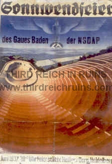
Left - period postcard showing the
Heiligenberg Thingstätte. Right - this poster advertised the Summer
Solstice Festival in June 1937, held at the Heidelberg Heiligenberg. By 1937, the
Thingstätte had been renamed "Feierstätte" (Festival Site). By this time the
"Thing" movement had declined, and the Thing places were largely being used for
folk fests instead of the original ideological meetings and propaganda theatricals.
(left - courtesy James Lees; right - author's
collection) |
Click here to
visit a "Third Reich in Ruins" page showing other Thingplatz/Thingstätte
sites.
 |
 |
| SA
troops march across the Alte Brücke
bridge in Heidelberg during the early days of the Third Reich. The
famous Heidelberg Castle is seen on the hillside beyond. ("Kampf
um's Dritte Reich," Altona-Bahrenfeld, Cigaretten-Bilderdeinst,
1933) |
-
|

|

|
| Schwetzingen
is a town west of Heidelberg. The period photo shows a parade of
Wehrmacht troops down the main avenue of the town in 1944. Click here
to see views of Schwetzingen in 1945, after the defensive fighting in
the area, with destroyed Jagdtiger vehicles. (photos
courtesy Dianne Polaski) |
Bamberg

|

|
When the 3rd and 45th
Infantry Divisions of the U.S. Army moved into the Franconian city of Bamberg on 13-14
April 1945, they found the defenders fighting from the rubble produced by repeated bombing
and artillery attacks. However, the defenders knew the futility of their actions and the
city was quickly surrendered, sparing it from the near-complete destruction experienced in
towns further west (although artillery rounds ignited a destructive fire that burned many
of the older wooden houses in the city). In the photo above, tanks and
infantry of the 45th Infantry Division (3/180 Infantry) clear a roadblock
on Hallstadterstraße, in front of the Oehlhorn & Wöltz factory. The
factory building has been changed, but practically all the other buildings
on this part of the street remain much as they appeared in 1945. (National
Archives RG 111-SC-333006; my thanks to Andreas Redel and the Bamberg
Stadtarchiv for identifying this location)
(MapQuest
Map Link) |
 |
 |
| When the
U.S. Army units reached the Kettenbrücke bridge over the Main-Danube
Canal, they found it blown by the retreating defenders, but other routes
allowed passage into the city. (National
Archives RG 111-SC-323994) (MapQuest
Map Link) (Note - This bridge is to be replaced in 2010 -
thanks to Dave Groß for the info.) |

|

|
Another view of the
same Panther tank on Zollnerstraße (presumably the same tank, although it
appears to have been moved slightly). Two characteristics of the Ausf. D
(the earliest Panther model) are evident in this photo - the simple cylindrical
commander's cupola,
and the rectangular armor flap covering the port for the bow machinegun. |
|

|
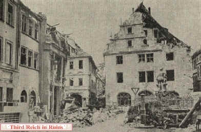
War damage to the
Grüner Markt area was severe. About the only item recognizable today is the Neptune
Fountain on the right, which Bambergers call "Gabelmann" (Fork Man) because of
his golden trident. (Stadtarchiv Bamberg) |
Other Miscellaneous Sites

|

|
In 1945 this was the control tower
for Kitzingen Army Air Base (used by the U.S. Army as Harvey
Barracks, but now closed), and the scene of one of the
more interesting examples of the German surrender at the end of the war. Famed Stuka pilot
Hans-Ulrich Rudel, only member of the German forces to have been awarded the Ritterkreuz
(Knight's Cross) with golden oakleaves, swords and diamonds, flew his unit here from
Czechoslovakia to surrender to the Americans on 8 May 1945. Rudel slammed his canopy shut
on the first GI to reach his plane, who had reached in and tried to steal Rudel's
one-of-a-kind decoration. (MapQuest
Map Link) |
German scientists worked on a
nuclear reactor, and possibly an atomic bomb, in the city of Stadtilm in Thüringen. A
laboratory for the development of nuclear power was located in the basement of this school
building in Stadtilm in 1945. The work was fairly far progressed when the war ended, but
there is little evidence that the Germans were anywhere close to developing an atomic
bomb (although persistent rumors of nuclear tests remain). This may have been due to Hitler's apparent skepticism that such a weapon was
possible. (MapQuest
Map Link) |
-

|
|
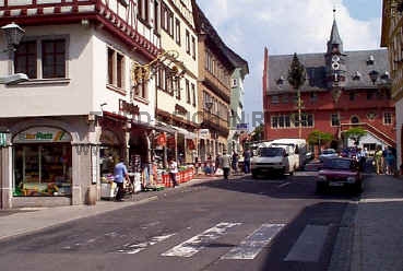
Ochsenfurt, on the
Main River south of Würzburg, was the scene of Nazi May Day
(Tag der Arbeit) marches. The city Maibaum (May Pole) can be seen in both views,
in front of the Rathaus in the distance. (Stadtarchiv Ochsenfurt)
(click here for another Ochsenfurt
site)
(MapQuest
Map Link) |
-
|

|

|
| The Wasserkuppe
is the highest point of the Rhön highlands, east of Fulda. The area has
been a popular spot for glider flights since the 1920s. Near the top of
the hill is a Fliegerdenkmal, or Flyers Memorial, erected in 1923
(some sources list this as a Nazi monument, but it was actually
earlier). These photos show an RAD (Reichsarbeitsdienst - Labor
Service) formation at the memorial in the 1930s, and the corresponding
view today. (MapQuest
Map Link) |
-

|

|
Sculptor Josef
Thorak, one of the premier artists who displayed in the annual Haus der Deutschen Kunst exhibitions, had a huge studio in
Baldham, a suburb east of Munich. The building was designed by Albert Speer and was
described as the largest studio in the world. The studio building still exists, but is not
open to the public. (Albert Speer, "Neue Deutsche Baukunst," Berlin,
1943 (author's collection) |
|


|
Thorak's
studio figured in the German military surrender at the end of the
war. The building had been taken
over by the advancing U.S. forces as headquarters for the XV Corps, and
German General Hermann Förtsch surrendered troops of Army Group G there
on 5 May 1945.
(U.S. Army Signal Corps Collection, National
Archives)
The side of the building
seen here is the back side, but it is the most accessible for viewing, being located just off Waldstraße in
Baldham. Today the building houses archaeological collections of the
Munich museums, and vegetation blocks the front view.
(MapQuest
Map Link) |
-
|
|
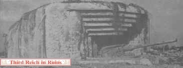
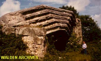
The Atlantikwall in France was an
elaborate defense system in the Calais area, but in Normandy, where the invasion actually
landed, the "wall" was more a system of isolated bunkers and gun positions.
However, some of these housed powerful artillery pieces, which dueled with Allied
battleships and destroyers on D-Day. Some of these positions held out for almost a week
following D-Day. The largest of these positions in the invasion area were near
Saint-Marcouf and Crisbecq, inland from Utah Beach. These housed 210mm naval guns in
reinforced concrete shelters. (U.S. Army) |
The concrete gun positions were
blown up by the Americans after their German defenders surrendered. These sites used to be
rather "out in the boonies" and overgrown, but they have recently been cleared
and marked for historical interpretation (this photo of one of the Saint-Marcouf positions
was taken in 1981).
(MapQuest
Map Link) |
-
 |
 |
| Members
of the British Union of Fascists (the "Blackshirts") lay a
wreath at the Cenotaph memorial, in the center of Whitehall Street near
Downing Street, in London, 1936. Among the Blackshirts in this photo is
likely their leader Sir Oswald Mosley. ("Illustrierter
Beobachter," 30 January 1936) |
 Proceed to Part
2
 Go to the War Memorials page Go to the War Memorials page
|
