|
Hitler's Walk to the Mooslahnerkopf
Teehaus
(text and images
submitted)
There were probably several
routes to (and from) the Teehaus. The red route which goes counterclockwise is
the most known one, but some photographs (see below) show a different (green)
route. So, there were probably different "outward-" and "return
routes".
And the story goes, sometimes Hitler walked to the Gutshof where
they picked him and his entourage of that day up and drove them back to the
Berghof. Again, bear in mind the red route differs from the modern path that one
can walk on nowadays.

|

|

|
|
Hitler’s daily walk to the
Mooslahnerkopf Teehaus from the Berghof. (Left - private
collection; right - excerpt from the "Kartenwerk
Obersalzberg" map by Max Hartmann, ca. 1940)
|
|

Copyright: Walter Frentz Collection, Berlin
|

|
|
After leaving the Berghof they
turned left, crossed the street and walked downhill counterclockwise.
(left - Walter Frentz Collection, used by permission)
|
|

|

|
|
Photomontage of the old and
current situation. Both photos are taken from
the Hotel
zum Türken.
(modern photo courtesy Kaspar Lyngsie)
|
This track is no longer
accessible and differs from the modern path.
|
|

Copyright: Walter Frentz Collection,
Berlin
|

|
|
Hitler and Himmler (reverse
angle), walk downhill from the Berghof. Martin Bormann’s house can
be seen in the background, through the trees. (left
- Walter Frentz Collection, used by permission)
|
|

|

|
|
The wooden walkway that made
its way down this hillside.
|
|

|

|
|
Same spot in another season.
|
Aerial view of the two turns
and the Berghof.
|
|

|

|
|
Further along this path,
looking back toward the Berghof in the background (still from Eva
Braun's movies in the U.S. National Archives).
|
|

|
|
|
Same spot - obviously before
it was a golf course! (still from Eva Braun's
movies in the U.S. National Archives)
|
|

|

|
|
Still with Speer and Hitler
walking clockwise back to the Berghof (Gutshof?).
|
The approximate location.
|
|

|

|
|
Speer
(?) and Hitler must have turned right and walked back to the Berghof
or perhaps the Gutshof (?). In contrast to the previous photograph,
there are clouds and the sun has gone. Perhaps another time of day? Or
another day entirely? (The Watzmann mountain is in the
background.) (screen capture from Google Earth ©)
|
|

Copyright: Walter Frentz Collection,
Berlin
|

|
|
Hitler and Walter Hewel (one
of Hitler's few personal friends) walking counterclockwise to the
Mooslahnerkopf Teehaus. (left
- Walter Frentz Collection, used by permission).
|
|

|

|
|
Same part of the route seen
from another perspective: the terrace of the Berghof (the path along
the grassy hillside in the background was the Teehaus route - stills from Eva
Braun's movies).
|
|

|

|
|
Hitler approaching the
Mooslahnerkopfhaus.
|
This is likely the exact
location (Hitler must have been on the "green route" - see
below).
|
|

|

|
|
The main path led directly to
the famous overlook at the Mooslahnerkopf. A side path to the left led
to the Teehaus itself. (Stills from Eva
Braun's movies in the U.S. National Archives)
|
|

|

|
|
The Mooslahnerkopf Teehaus.
The famous overlook can be seen in the right background.
|
|
|

|
|
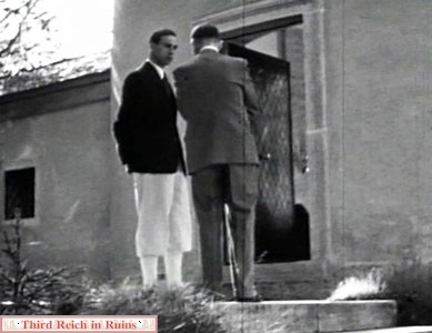
Hitler (in front of the
entrance of the Mooslahnerkopfhaus) talks with Dr. Karl Brandt.
|
Hitler enters the
Mooslahnerkopfhaus.
|
|

|

|
|
Hitler talking to children in
the Mooslahnerkopfhaus (these four photos are stills from Eva
Braun's movies in the U.S. National Archives).
|
|

|

|
|
Hitler with
Foreign Minister Joachim von Ribbentrop
in the Mooslahnerkopfhaus - stills
from Eva Braun's movies.
|
|

|

|
|
Hitler
with Joachim von Ribbentrop.
|
Not much has changed.
|
|

|

|
|
Hitler takes an
"alternative" route and walks clockwise to the
Mooslahnerkopf Teehaus; the green route on the map at the top of this
page, and the aerial photo below.
|
This path went past the Villa
Bechstein, and across the Gutshof meadow (modern golf course).
|
|

|

|
|
The path no longer exists, but
the Google Earth screenshot shows the approximate location. The
buildings seen in the background are, left-right: the Heustadl hay
barn (above the left group of walkers), Albert Speer's house and
studio (light colored roofs), and the Gutshof (just behind the right
group). (left - U.S. National Archives, RG 242-EB; right -
Google Earth ©)
|

The Teehaus routes marked on an aerial
photograph taken ca. 26 April 1945, after the bombing of the Obersalzberg.
Both paths start at the Berghof, in the lower right center, and the Teehaus is
circled in yellow at the upper left.
(U.S. National Archives, RG 373, Sortie 7-147D, #3061)
Unknown Spots I
|

|

|
|
The path runs along the hill
towards the Watzmann. Note: the light seen at the end of the track in
the distance, is a car (still from Eva
Braun's movies in the U.S. National Archives).
|
Google Earth printscreen from
the same perspective. The path on this printscreen runs on a flat part
and cannot be the same path as seen in the movie still. (Google
Earth ©)
|
|

|

|
|
The
above mentioned car (from the opposite side) that picked them up.
|
Is it this area?
|
Unknown Spots II
|

|

|
|
These
two spots are probably very close to each other, but where? (stills
from Eva Braun's movies in the U.S.
National Archives)
|
Unknown Spots III
 Return
to the Mooslahnerkopf Teehaus page Return
to the Mooslahnerkopf Teehaus page
 Continue to other Obersalzberg sites - Hitler's
Berghof, Bormann's and Göring's houses, Platterhof, Gästehaus and Kampfhäusl,
Hotel zum Türken,
Kehlsteinhaus, SS barracks, bunker system, miscellaneous buildings,
other miscellaneous area buildings, area Flak
Battery positions.
Continue to other Obersalzberg sites - Hitler's
Berghof, Bormann's and Göring's houses, Platterhof, Gästehaus and Kampfhäusl,
Hotel zum Türken,
Kehlsteinhaus, SS barracks, bunker system, miscellaneous buildings,
other miscellaneous area buildings, area Flak
Battery positions.
Return to the Third Reich in Ruins homepage
 |
My guide
book to Third Reich sites in the Berchtesgaden and Obersalzberg area has
been published by Fonthill Media.
"Hitler's
Berchtesgaden" is available at Amazon and other retailers (the
Kindle version is also available from Amazon). |
|


