|
Wehrmacht Posts
/ Kaserne
Shortly after taking
power in 1933, the Nazis began a program to build and modernize military posts
all over Germany. Some older Kaserne were remodeled as part of this program, but
most posts were new construction. Several different architectural styles were
used, as the Third Reich architects wished to blend their military posts into
the style of the local area, but all Kaserne shared a basic look.
Part 1 features posts in the
following Bavarian locations: Ansbach, Schweinfurt,
Bad Kissingen, Würzburg, Kitzingen,
Wildflecken, Bamberg, Fürth, Schwabach,
Augsburg.
Part
2 features posts in the following locations: Bavaria - Grafenwöhr, Bad
Tölz, Berchtesgaden, Bad Reichenhall, Garmisch, Munich; Hessen - Butzbach, Giessen, Frankfurt,
Fulda, Bad Hersfeld; Baden-Württemberg - Karlsruhe; Part 3 features
posts in Thüringen - Meiningen ; Bavaria - Füssen; Rheinland-Pfalz -
Baumholder, Bad Kreuznach; Baden-Württemberg - Schwetzingen, Mannheim,
Heidelberg, Wertheim;
Hamburg; Niedersachsen - Bergen-Hohne, Wolfenbüttel; Hessen - Friedberg,
Gelnhausen.
Note: This page shows only a few such sites
... I would be very pleased to hear from anyone who would like to share similar
then-and-now photos from other Wehrmacht posts in Germany. Contact me at:
walden01 (at) comcast.net.
To view various Wehrmacht
Kaserne sites in northern Germany, visit the Forgotten
History page.
Note: After abandonment
by the military and return to the German government, many 1930s-era Kaserne are
either partially or totally torn down, so the buildings shown here in modern
photos may no longer be there.
Ansbach
|

|

|
| The
"Kaserne auf der Ludwigshöhe," also known as the Artillerie
Kaserne and the "Gneisenau-Kaserne," was built in the Franconian
city of Ansbach in 1934-35. This post is used today by the U.S. Army as
Barton Barracks. For further info, see the U.S.
Army in Germany page. (from period postcards) (Google
Maps link) |
|

|

|

|

|

|
| Bleidorn
Kaserne in Ansbach was built in 1935-36 for Reconnaissance Battalion 17. This view is almost identical today, minus the
gateposts and flag, and also minus the Reichsadler stone eagle that can
be seen in profile on the wall to the right - this eagle (minus its head
and swastika) was still there when the U.S. Army was in this Kaserne in
the 1950s, but was removed at some point since. This post is now used by
the German Polizei. The buildings retain military sculpture above the
doorways - left-right, below - cavalry, artillery, a soldier says
farewell to the home folks, banner bearers. (Google
Maps link) |
|

|

|

|

|
Schweinfurt

|

|
The Schweinfurt
Panzerkaserne (or Adolf-Hitler-Kaserne) was built in 1935-36 for Panzerregiment 4, and was
located on Niederwerrnerstraße. This post was used by the U.S. Army as
Ledward Barracks until it closed in September 2014. This postcard view shows the
Panzerkaserne in 1940. (MapQuest
Map Link)
Click here
to visit Heinz Leitsch's page on the USAG Schweinfurt (in German - auf
Deutsch).
2018 Update - The original buildings
of the Panzerkaserne are being demolished, to make way for a school
complex. The two buildings seen above MAY be saved. |
 |
 |
Click here
to see many more photos of the Panzer Kaserne in Schweinfurt.
-

|

|
Adjacent
to the Panzerkaserne was the Panzerabwehrkaserne,
built across the street to the east to house Panzerjäger Abteilung 38 (38th Anti-Tank Battalion).
This monument near the east gate of the former Ledward Barracks honors the dead of PzJgrAbt.
38, which served in the 2nd Panzer Division. Only three buildings of the
Panzerabwehrkaserne still exist, behind the park where
this monument is located (this park, the adjacent Youth Center, the Schweinfurt Stadtwerke (city
services) complex, and the Mercedes-Benz complex now occupy the area of
the former Panzerabwehrkaserne). Click here
to see a monument to Panzerregiment 4 in Schweinfurt. |
-

|

|
A Flugplatz or
Fliegerhorst (airfield) was built on the western outskirts of Schweinfurt in 1937. Training for Stuka
dive-bomber pilots was conducted here.
This Luftwaffe eagle appears on the gate building at the main entrance. The
post was used by the U.S. Army as Conn Barracks until it was closed in
September 2014. |

The Schweinfurt Flugplatz during the bombing
attack of 14 October 1943 (the attack was aimed at the
Schweinfurt ball bearing factories, not the military installations). Close
observation reveals 7 or 8 tiny aircraft (type unknown)
parked on the airfield. For orientation, north is to the upper left. (National
Archives, RG 343-FH 3A22430)
Click here
to see more photos of the Schweinfurt Flugplatz.
|

|

|
| The
trainee Ju-87 Stuka pilots flew from the Schweinfurt Flugplatz to a small bombing range near
Sulzheim, southeast of Schweinfurt. Here they practiced their
dive-bombing techniques with both live explosive bombs and concrete
practice bombs. The remains of many of these concrete bombs can still be
seen at the site today. (MapQuest
Map Link) |
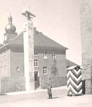
Bad
Kissingen
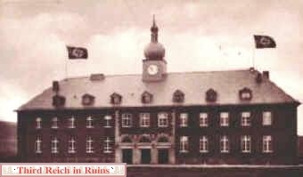
|

|
The
spa town of Bad Kissingen in northern Bavaria was garrisoned by Wehrmacht motorcycle
troops in the late 1930s. In 1936-37 Manteuffel Kaserne, named in honor of Freiherr von
Manteuffel of old dragoons fame, was built to house these troops. Later, units of the 2nd
Panzer Division occupied the barracks. Following the end of World War II, the area was
briefly occupied by the U.S. Army Air Forces XII Tactical Air Command. In the early 1950s
the post was occupied by U.S. Army border guard troops and renamed Daley Barracks.
The major tenant unit during most of the Cold War was the 2nd Squadron,
14th Armored Cavalry Regiment from 1951 until it was reflagged as the 11th
Armored Cavalry Regiment in 1972. 2/11ACR used the old Manteuffel Kaserne HQs
building as its dining facility. (Click here to
visit the area of OP Sierra, one of the border sites guarded by 2/11ACR.)
Daley Barracks was closed following the
reunification of Germany and returned to the German government ca. 1995. Most of the old
military buildings were torn down in 1998, but a few remain. The former headquarters
building now houses several businesses, and additional business buildings
are being built on the site. (MapQuest
Map Link)
(Some period views and historical
information in this section from the Border Trooper page, http://members.nbci.com/bordertrooper/manteuff.htm, except where
noted; period postcard views also from "The Crusader" newspaper,
Vol. 8, No. 43, 31 October 1984, page 7.)
For more info, visit the Daley
Barracks webpage, http://www.daley-barracks.de/. |
|

|
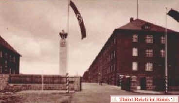
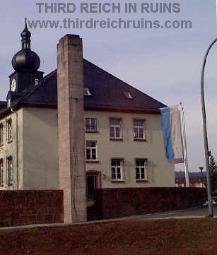
The
front gate was guarded by a stone pillar with the national insignia on top. The building
at the left of the photo is the former headquarters building. The barracks building on the
right has been torn down. The building in the distance of the modern photo is one of the
new business buildings built ca. 1998. |
|
|
Soldiers
marching through the front gate. This photo and the next two period photos are from the
service album of a soldier who was stationed at Manteuffel Kaserne (private
collection). An exact corresponding view today is blocked by the post-war building at
the left of the modern view. |
|
|
Above
- A
sentry stands guard at the main gate, with the headquarters building behind.
Below - A close-up of the eagle and swastika on the gate pylon. (private
collection) |
 |
 |

|

|
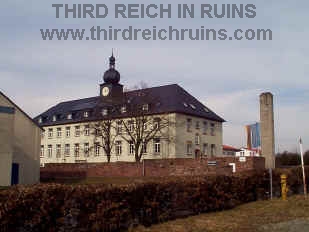
The eagle and
swastika Hoheitszeichen are long gone, but the gate pillar still proclaims the
site as Manteuffel Kaserne. |
Guard mount near the main gate (private
collection). |
|

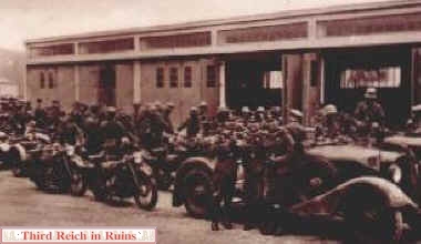
|
Motorcycle
troops in front of their motor pool maintenance shops. Some of the former
motor pool buildings are still standing. |
|

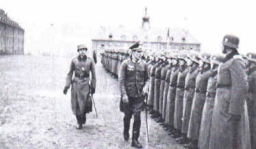
|
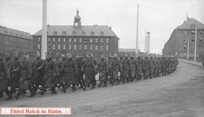
Military
review on the parade ground of Manteuffel Kaserne, ca. 1938. (period photo from a private collection) |

|

|
The
spa facilities in the town of Bad Kissingen were popular with the garrison troops. The
Arcade is seen above in a view from a soldier's photo album - note the swastika hanging in
the center of the upper story. Below, tanks with mounted infantry from the
U.S. Third Infantry Division roll across an engineers bridge in Bad
Kissingen in April 1945. (above - private collection; below -
U.S. Army photo) |
 |
|

|
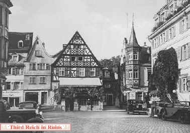
The
quaint Marktplatz downtown was also popular for soldier visits. (private
collection) |

|
On 20 April 1939 the buildings on
the Marktplatz were decorated in commemoration of Adolf Hitler's 50th birthday.
(Stadtarchiv Bad Kissingen) |
Würzburg
|

|

|
| In 1936
Generalmajor Heinz Guderian, commander of the German armored forces (in left
foreground) visited the newly-built Nord-Kaserne on Veitshöchheimer
Straße, northwest of the Würzburg city center. In the 1936 photo Guderian is
seen with the Kaserne Kommandant, just in front of the main gate
guardhouse seen on the other side of the gate in the photo below. (MapQuest
Map Link) |
U.S. Army Emery Barracks in the 1970s,
when the eagle and knight were painted.
(courtesy Stephen L. Cobb)
|

|
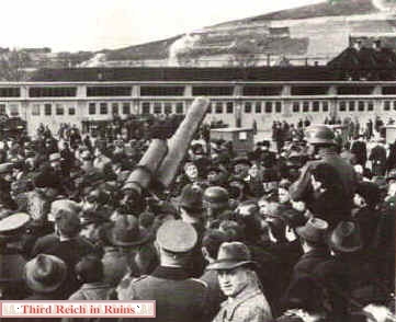
The
display for the March 1939 Tag der Wehrmacht (Armed Forces Day) included 150mm
artillery pieces at Hindenburg Kaserne. This post no longer exists, but the
photo on the right from ca. 1979 shows the same view. (Stadtarchiv
Würzburg; modern photo courtesy Tom
Crowder) |
-

|

|
A
large military hospital complex was built in Würzburg in
1936-37. When the U.S. Army moved into the area in April 1945, this facility was
taken over by the 107th EVAC Hospital, and it continued to serve as a U.S. Army hospital
until it was returned to the German government in 2007. The historic
hospital building was extensively remodeled into an apartment building in
2010-2011. (1945 photos courtesy Frank Tompkins - visit Frank's site about the
107th EVAC Hospital)
(MapQuest
Map Link) |

The new occupants chiseled the swastika from
beneath the eagle over the
main doorway,
painted "107 EH" where the swastika had been,
and painted the eagle itself red, white, and blue
(this eagle has since been removed). (courtesy Frank Tompkins)
 |
 |
 |
| Fortunately,
the conversion of the hospital building into an apartment complex did
not remove the historic military sculptures at the top of the façade
above the main entrance. These sculptures depict wounded servicemen from
various services, some being assisted by nurses and some by their fellow
servicemen, along with soldiers on service (on the right above, and
infantryman and panzer crewman (in panzer wraparound tunic and soft
"helmet" beret) consult a map; on the left below, two artillerymen
work on a large projectile). |
 |
 |
 |
|

|
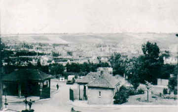
Looking from the
hospital entrance, past the gates, to the Main River valley and the vineyards on the hills
beyond. |
Kitzingen
|

|

|
|
Two military posts were built
in Kitzingen on the Main River, east of Würzburg. In this photo,
soldiers stand in formation inside the front gate of the Kitzingen
Flugplatz (or Fliegerhorst), built in 1934-35. This is the airfield
where famed Stuka pilot Hans-Ulrich Rudel surrendered to the U.S. Army
in 1945 (see here).
The post was used by the U.S. Army as Harvey Barracks until it was
closed in late 2006; it is now used by a private corporation. (original photo in author's collection)
(Google
Maps Link)
|
 |
 |
| A
quarters area for officers, including a Casino (Officers Club) was
across the road from the Kaserne. Stylized wings representing the Luftwaffe can still be
seen in the iron window grillwork of a stone outbuilding. Note: All
the buildings shown in the Kitzingen section are now closed, and these
posts have been returned to the German government. |
Wildflecken
|

|

|
A
large military post with training area was built in the Rhön
highlands in northern Bavaria and adjacent Hessen, near the town of
Wildflecken, in 1936-38. The training area was popular with Panzer
units, particularly from the Waffen-SS, although the harsh Rhön
climate could lead to miserable times (for soldiers then and now),
producing the Landser saying "Lieber den Arsch
voller Zecken als ein Tag in Wildflecken!" (better an ass full of
ticks than a day in Wildflecken). The post was used after the
war by the U.S. Army, and is now used by the Bundeswehr as the Rhön-Kaserne.
The period photo shows a soldier formation on the Adolf-Hitler-Platz,
which is hardy changed at all today. (Wildflecken Museum)
(MapQuest
Map Link)
Visit the
Comrades.de Wildflecken page |
|

|

|
| SS
chief Heinrich Himmler visits Waffen-SS trainees at Wildflecken. Seen
to Himmler's left are Gauleiter Otto Hellmuth (in rear), Youth Leader
Artur Axmann, unknown (in rear), Gerhard Hein. The modern view has
been pulled back a little to show more of the buildings in the
background at the side of the former Adolf-Hitler-Platz. (Wildflecken
Museum) |
|

|

|
| Another
parade in the Adolf-Hitler-Platz, with members of the 5th SS
Panzergrenadier Division "Wiking." (Wildflecken
Museum) |
|

|

|
| Pzkw.
III tanks of the 5th SS "Wiking" Division convoy down one of
the main streets on the Kaserne. (Wildflecken Museum) |
|

|

|
| This
barracks building, shown on the left in a 1939-dated postcard,
exhibits the general style of many of the buildings on the Wildflecken
Kaserne. (author's collection) |
|

|

|
| Soldiers
march down the street alongside barracks buildings, from a 1939-dated
postcard. (author's collection) |
|

|

|
| Soldiers
load a truck in front of one of the Wildflecken barracks buildings.
(Wildflecken Museum) |
 |
 |
 |
| Although
the Kantine (Club) building has seen several changes, it is still
recognizable. On the left, from a 1939 postcard; on the right, from a
soldier's photo. (author's collection) |
 |
 |
| In
1940 a memorial stone was erected to honor the workmen who died during the
construction of the Wildflecken post. The photos above show the unveiling of
the monument. The monument still exists, but it is located today beside the
post museum, and the original memorial tablet has been replaced. (Wildflecken Museum) |
 |
Click here
to see a nearby munitions factory bunker storage area at Oberwildflecken.
Bamberg
|

|

|
| Two
Kaserne were built in the Franconian city of Bamberg in 1935-36. Both
were on Zollnerstraße - one a Panzerkaserne (occupied by Panzerregiment
35 of the 4th Panzer Division) and the other an Artilleriekaserne.
The two posts together were used by the U.S. Army as Warner
Barracks until closed in September 2014. This building is near the
Zollnerstraße gate. (MapQuest
Map Link) |
 |
 |
| This
headquarters building is near the center of the post, by the parade
field. |
Fürth
|

|

|
|
A Fliegerhorst, or
Luftwaffe post, was built in Fürth (near Nürnberg)
from 1934-39, by modernizing and enlarging an existing World War I
airfield. The photos above show the front gate. The post was used by
the U.S. Army as Montieth Barracks from 1945-1995. It is now partly in
use by small businesses. (U.S.
Army in Germany page) (MapQuest
Map Link)
|
|

|

|
|
On the left is a view ca. 1937
showing bi-planes and their crews - the hangers and administration
building in the background can be seen in the modern view.
|
Schwabach
|

|

|
|
Another Kaserne in the Nürnberg
area was the Nachrichtenkaserne (Signals Post) in Schwabach. This post
was built in 1936-37 for Signals Battalion 17. After the war it was
used by the U.S. Army as O'Brien Barracks, but was returned to German
control in the early 1990s. Many of the buildings have since been torn
down, but some remain - the gate building on the left is now the city
museum. (U.S.
Army in Germany page) (MapQuest
Map Link)
|
Augsburg
|

|

|
|
Somme Kaserne (named for
the WW1 battle in France) was built in Augsburg in 1934-35 for
Artillerie Regiment 27. The post was used after the war by the U.S.
Army as Reese Barracks, but since the Army's departure in 1994 some
buildings were demolished and most of the remainder are unused. The
building above still shows period artillery artwork, and is used today
as the "Kantine" club. (U.S.
Army in Germany page) (Google Maps
link)
|
|

|
 Continue
to Part 2, featuring the Bavarian sites of Grafenwöhr, Bad Tölz,
Berchtesgaden, Bad Reichenhall, and Garmisch; Butzbach in Hessen; and Meiningen
in Thüringen.
Continue
to Part 2, featuring the Bavarian sites of Grafenwöhr, Bad Tölz,
Berchtesgaden, Bad Reichenhall, and Garmisch; Butzbach in Hessen; and Meiningen
in Thüringen.
 Back to the
Third Reich in Ruins
homepage
Back to the
Third Reich in Ruins
homepage
|


