|
Würzburg
Würzburg is a beautiful Baroque city, the
capital of Unterfranken (Lower Franconia). Although there were some military installations
in the city, it was not an important target, and it largely escaped the repeated bombing
that devastated many German cities. A few bombs had been dropped, and lives lost, in June
1944, and heavier bombing came in February 1945, but the destruction had not been
widespread. Until, that is, 16 March 1945 ... on that night, a fleet of 280
British RAF bombers dropped some 1200 high explosive and 380,000 incendiary bombs
-- 927 tons of bombs -- on Würzburg. The incendiaries started a
firestorm in the old wooden houses that eventually consumed nearly 90 percent of the city.
The total civilian casualties will never be known, but numbered at least 3000,
and perhaps as many as 5000. When the
U.S. Army entered Würzburg on 3 April 1945, the soldiers found little more than a ruin of
rubble and ashes (see Part 2). Click
here
for a MapQuest map link to Würzburg.
|
|
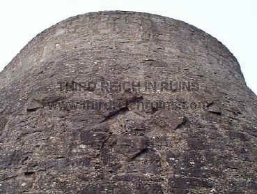
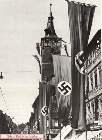
Würzburg was brought
into the Nazi fold soon after their assumption of power in 1933. This so-called
Adolf-Hitler-Turm, built on the Hohenrothberg hill above Randersacker, was
erected in 1938 as a base for a flagpole
bearing a huge swastika flag that could be seen up and down the valley of the Main River,
south of the city. This edifice (now called the Sonnenstuhlturm,
or the Potato Tower by locals)
can still be seen today by anyone traveling the A3 Autobahn past Würzburg, on a hill overlooking the river between the Biebelried and
Randersacker exchanges (the tower is most easily seen just as you cross the
Autobahn bridge over the Main River, on the hill just across the river to
the north). Post-war efforts to obliterate the large stone swastikas on three
sides were not entirely successful (one source says this damage was caused
by U.S. Army tankers firing at the tower from across the Main River, but
this seems unlikely). (MapQuest
Map Link) |
|

|

|
| On the
left, a view of the tower from the rear, showing the stone walkway to
the top and the base for the flagpole. On the right, a close-up view of
the remains of the swastika and date 1933 on the front of the tower. |
|

|

|
| This edifice was actually started in the 1920s as
an observation platform, but was turned into a flag tower by the Nazis. |

|

|
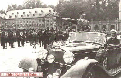
When
Adolf Hitler visited Würzburg, he was generally lodged in the Würzburger Hof hotel on
the Barbarossaplatz. Hitler is shown here in front of the hotel during a visit in
August 1933.
Hitler was present for several Nazi parades and ceremonies in Würzburg. The
sign on the hotel that appears to show a Star of David was actually an
advertisement for the Würzburger Hofbräu, the city brewery. (Bundesarchiv) |
|

|
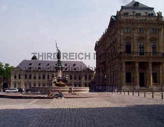
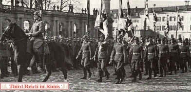
Many
of the Nazi ceremonies took place in the large open area in front of the Residenz, the
18th century rococo palace of the Prince-Bishops of Würzburg. On 10 March
1933, the newly-empowered Nazis burned pamphlets and writings by
Communists here in the Residenzplatz. In this photo, Adolf Hitler
visits on 27 June 1937. (Stadtarchiv Würzburg) |
|

|
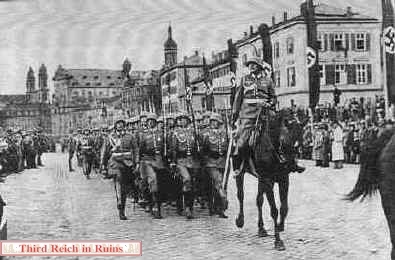
Parade
in honor of Hitler's 50th birthday, 20 April 1939, in the Residenzplatz. (Stadtarchiv
Würzburg) |
The following photos show various Nazi parades in
the Residenzplatz. (Stadtarchiv Würzburg)

|

|
The
Nazi Gauleiter of the Main-Franken area, Dr. Otto Hellmuth, was married in the Residenz in
June 1936. The wedding procession was pictured in the Residenzplatz, in front of the
fountain crowned by the statue of Franconia. In the right-center distance are the spires
of the Würzburg Dom (St. Kilian's Cathedral); in the left distance appears the Marienberg
Fortress on the hills across the Main River. Most of the buildings in this view were
bombed and burned out in March 1945. (Stadtarchiv Würzburg) |
|

|
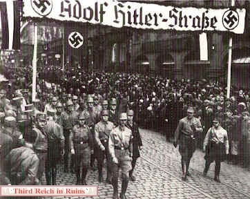
As in
other German cities and towns, one of the major Würzburg streets was renamed
Adolf-Hitler-Straße, shown here during an SA parade in the 1930s. This is now
Theaterstraße, and is home to one of Würzburg's McDonald's restaurants. (Stadtarchiv
Würzburg) |
-
|
|
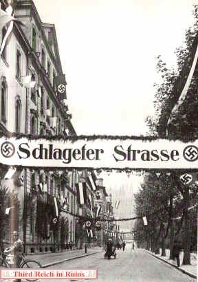
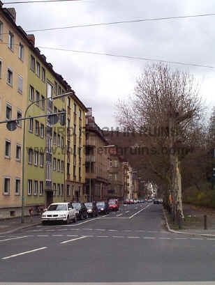
Sanderglacisstraße,
near the Main River, was renamed in honor of Albert Leo
Schlageter, a German nationalist
who had been killed by the French in the French-occupied Ruhr in 1923. (Stadtarchiv
Würzburg) |
|
|
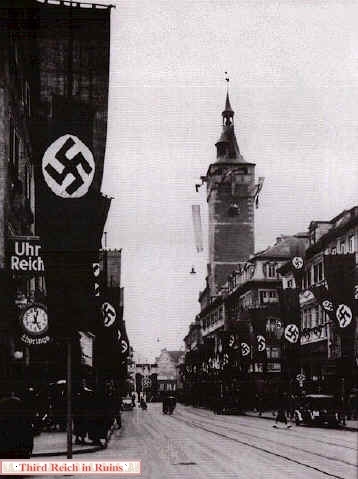
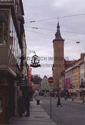
The
Domstraße, leading from St. Kilian's Cathedral to the Main River, is dominated by the
tower of the Alte Rathaus (Old City Hall). (Stadtarchiv Würzburg) |
|

|
The
March 1945 bombing destroyed the Rathaus tower roof and bell tower, which were rebuilt in
the same style; not so for many of the surrounding buildings. The period
photo shown here was taken on 30 April 1938. (Stadtarchiv
Würzburg) |
|

|
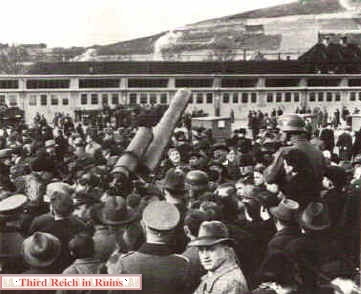
The
display for the March 1939 Tag der Wehrmacht (Armed Forces Day) included 150mm
artillery pieces at Hindenburg Kaserne. This post no longer exists, but the
photo on the right from ca. 1979 shows the same view. (Stadtarchiv
Würzburg; modern photo courtesy Tom
Crowder) |
|

|

|
| In 1936
Generalmajor Heinz Guderian, commander of the armored forces (in left
foreground) visited the newly-built Nord-Kaserne on Veitshöchheimer
Straße, northwest of the city center. In the 1936 photo Guderian is
seen with the Kaserne Kommandant, just in front of the main gate
guardhouse seen on the other side of the gate in the photo below. (MapQuest
Map Link) |

|

|

|
| The
Nord-Kaserne was named Adolf-Hitler-Kaserne in 1938, which is shown by
the name plate on the gate post on the other side of the entrance.
Hitler's name and the accompanying swastika were chiseled off after the
war. The gate post also features an Iron Cross in a shield and a relief
of a medieval standard-bearer. The Reichsadler at the corner of
the other gate building presumably once grasped a swastika. The U.S.
Army used this post as Emery Barracks until ca. 1995. |
|

|

|

|
|
The
parade for the May 1933 Tag des Handwerks (Factory Workers Day) passed by the Kilian
Fountain in front of the Bahnhof. (Stadtarchiv Würzburg) |

|

|
The
local Nazi leadership conducts a ceremony at the Würzburg World War I
memorial on 14 March 1938. The memorial was by Würzburg sculptor Fried
Heuler. (Stadtarchiv Würzburg) |
|

|

|
| A Studentenstein,
or Student Memorial, was erected near the Würzburg University in 1927,
to honor the German students who had gone to war in World War I. On the
left above, a ceremony at the Studentenstein remembers the dead
on Langemarck Day, 11 November 1933 (many of the dead in the battle of
Langemarck in November 1917 were student volunteers). The Nazis modified
the memorial's design, adding swastikas but retaining the words
"Deutschland Muss Leben Auch Wenn Wir Sterben Müssen"
(Germany must live, even if we must die). The memorial was modified
again after the war, removing the engravings and adding bronze plaques
in honor of death, sacrifice, and example. |
|

|

|
|

|

|
| The
Luitpold Hospital was built on a prominent hill in 1932-34. When this
period photo was taken in 1940, the buildings had Red Cross flags on
their roofs. The complex is today a part of the University Hospital. The
smoke stack (which may also be a water tower) was jokingly called
"Hitler's Penis" by locals. (Stadtarchiv Würzburg) |

|

|
A
large military hospital complex was built in Würzburg in the late 1930s. When the U.S.
Army moved into the area in April 1945, this facility was taken over by the 107th EVAC
Hospital, and it continued to serve as a U.S. Army hospital until returned
to the German government in 2007 (the hospital was extensively remodeled
in 2011). (1945 photo
courtesy Frank Tompkins - visit Frank's site about the 107th EVAC Hospital) --
see the Wehrmacht Military
Posts page for other
pictures of this site. See also http://www.wuerzburg-photos.de/barracks.html
(in German), which has photos of the hospital and other military sites in
Würzburg. |

|

|
This building of
apparent Third
Reich architecture is located down the street from the hospital in the photos
above (across from the Gaubunker, see below), but I
have been unable to discover its 1930s function. |
|

|
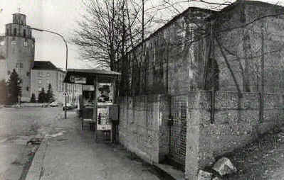
The
concrete structure in the postwar photo on the left was a command and control bunker for
the local Nazi political control unit (Gaubunker). It remained for some years after
the war, but the upper part was removed in the 1960s or 1970s. The lower portion, and
perhaps any underground rooms, remain today just down the street from the
military hospital (which
can be seen in the background in the modern photo). Note
- these bunker remains were removed in 2005 during construction of a new
gate for the military hospital. (Stadtarchiv Würzburg) |

Nazi Gauleiter Dr. Otto Hellmuth lived
in this villa on Rotterdorfer Straße (renamed Ludendorffstraße during the Nazi
period). The home had been a forced sale from a Jewish druggist in 1938. It is
across the street from the Gaubunker, where Hellmuth and his family took refuge
during the bombing attacks.

|

|
|
The Würzburg headquarters of the
NSV (Nationalsozialistische Volkswohlfahrt - Nazi People's Welfare Organization)
were
located at Ludwigkai 4, along the Main River. Also in this building were the
headquarters of the local Nazi Womens League, including a school for
mothers. This building was taken over in 1945 for the headquarters of the
U.S. Army occupation force, and it served until the early 1990s as the
Military Police station. The building still shows classic elements of
Nazi architecture. |
 |
 |
| This
building at Leistenstraße 121 was the Gauschule - a training site for
functionaries of the local government. Today it is a private residence. |
 |
 |
This Fachwerk building in the
Würzburg suburb of Heidingsfeld was the local Hitler-Jugend Heim. (Gerdy
Troost, "Das Bauen im neuem Reich," Bayreuth, 1942)
|
National Socialist Buildings in Würzburg -
guide with maps and photos (in German) --
http://uploader.wuerzburg.de/gym-fkg/schule/fachber/gesch/facharb/kiesel/karte.htm
 Continue to Part 2, Würzburg During the War Continue to Part 2, Würzburg During the War
 Back to the Third Reich in Ruins homepage
|