|
Miscellaneous Sites
Associated with the Third Reich
Part 4
The following sites can be found
on this page. Click these links to proceed directly to a particular site: Bunker
site near Ansbach (Bavaria), bunker site in
Bavarian training area, Nazi war memorial in Münchberg
(Bavaria), Adolf Hitler Tower near Uslar (Lower Saxony),
Hitler at the Kaiserpfalz in Goslar (Lower Saxony), Hitler
Youth School and other sites in Braunschweig
(Brunswick, Lower Saxony), air-raid shelters and other sites in Fürth
(Bavaria), Reichs Finance School in Herrsching
(Bavaria), Göring's Veldenstein Castle (Bavaria)
Adolf Hitler Platz in Muggendorf (Bavaria), Nazi
monument in Hilpoltstein (Bavaria), military ceremony in
Grafenwöhr
(Bavaria), Reichs Farmers School in Mindelheim
(Bavaria), Rheinhotel Dreesen at Bad Godesberg
(Nordrhein-Westfalen).
-
|

|

|
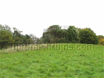
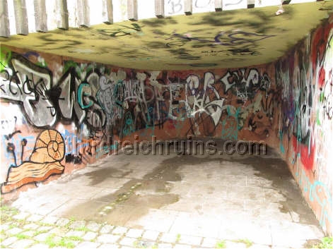
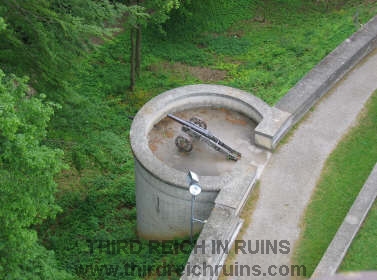
| At the end of
the small arms ranges (valleys formed by long earthen berms) is a subterranean room beneath
the end berm, for the target scoring and changing personnel. This room has a large opening in the
roof through which the targets were raised and lowered. Click here
to see a similar range with the target changing machinery still in
place. |
-
|

|
|
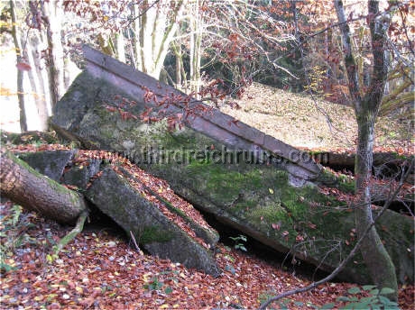
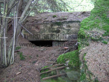
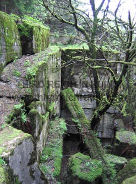
| This
bunker site is located inside a military training area in Bavaria. It
was apparently built in 1938-39 to train paratrooper units in assaulting
Fort Eben Emael on the Belgian frontier (Operation Granite), or possibly
other French-style fortifications (either the Maginot Line itself, or Czech
border fortifications, many of which were similar). The site consists of
a large bunker with three gun/observation turrets, and firing embrasures
for other guns. |
|
|
|
| The roof
of the main bunker has been demolished, revealing the deep interior and
the cylindrical mounting sites for the metal turrets. Tunnels lead to other nearby
bunkers (also demolished). |
|

|

|
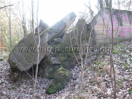
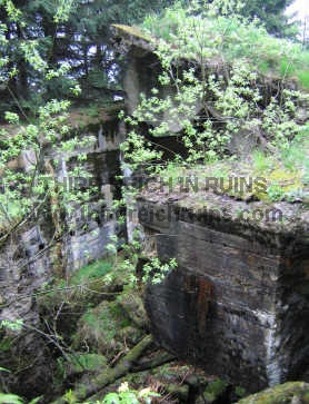
| One of
the metal turrets remains, dismounted from its mounting site in the
concrete base. This turret is similar to some found at Eben Emael, as
well as the Maginot
Line and the Czech border forts. |
|
|
|
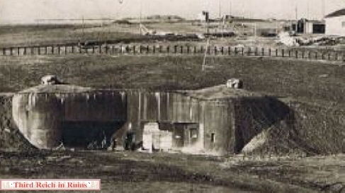
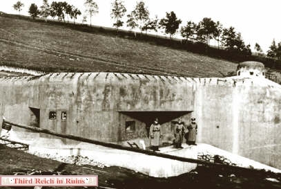
| Details
from period postcards showing Czech border fortifications (the one on
the left above near Grulich in the Sudetenland).
These bunkers are very similar to the ruins shown above. |
 |
-
 |
 |
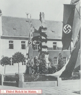
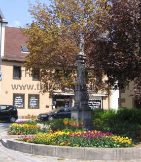
| A
memorial tower to the World War I dead was erected on the Rohrbühl hill
in Münchberg, in far northeast Bavaria, in 1935-37. The site is
practically unchanged today, except for the removal of the eagle and
swastika over the doorway (a memorial sarcophagus on the inside of the
tower (not open today) was also removed). (Google
Maps link) |
 |
 |
-
 |
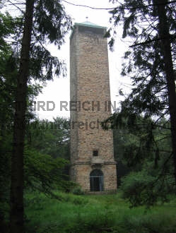 |
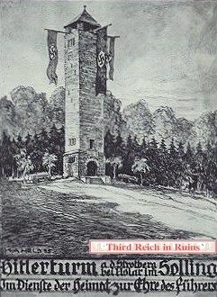
| An
existing lookout tower called the Sollingturm, in the wooded hills above
Uslar in Niedersachsen, was adapted and remodeled in 1934-35 as a
"Hitlerturm" - Adolf Hitler Tower (similar to the Bismarck
Towers of an earlier age). The caption at the bottom of the period
postcard reads "In service of the homeland for the honor of the
Führer." (Google
Maps link) |
-
 |
 |
| Hitler
reviews an honor guard in front of the Kaiserpfalz castle in Goslar
(Harz) on 30 September 1934, during the Agricultural Day celebration. At
the far left is then-Major Erwin Rommel (wearing his Pour le Mérite
"Blue Max" medal from the First World War), who was commander
of the elite Goslar Jäger Battalion of the 17th Infantry Regiment. On
this occasion, Rommel arranged the honor guard so that his Jäger troops
stood in front of the SS. Hitler left from here to attend the Harvest
Thanksgiving Festival on the Bückeberg. (Google
Maps link) |
-
|
|

|
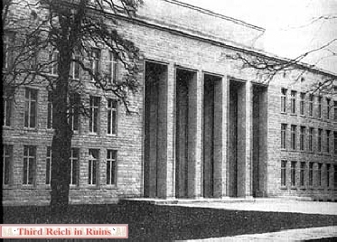
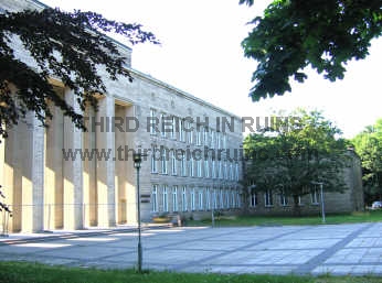
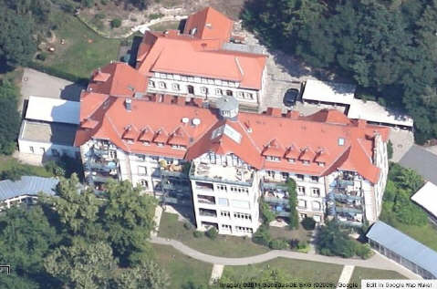
| A
"Reichsakademie für Jugendführung," or Adolf Hitler School
for Hitler Youth Leaders, was built in Braunschweig (Brunswick)
in1937-39. Designed in classical style by architect Erich zu Putlitz,
the complex was meant to be an elite school to train future leaders of
the Third Reich. The Academy opened shortly before the beginning of
World War II, and was used during the war as a training school for the
female labor service and Hitler Jugend (BDM), as a Luftwaffe hospital,
and finally as a school for disabled soldiers. The Academy exists today,
virtually unchanged, as the Braunschweig Kolleg on Wolfenbüttleler
Straße, an adult education facility. (Google Maps
link) |
|

|
|
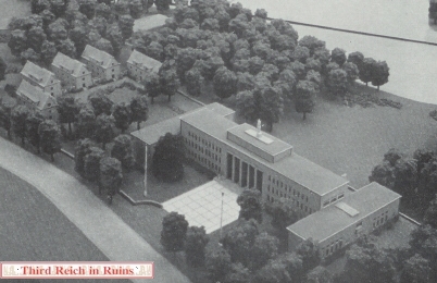
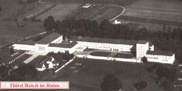
| This
model of the main Academy building shows how it was flanked by two
smaller wings. The monumental sculpture designed for the top of the
building by Georg Kolbe was never installed. (Herbert Hoffmann,
"Deutschland baut," Stuttgart, Verlag Julius Hoffmann, 1938) |
|
|
|
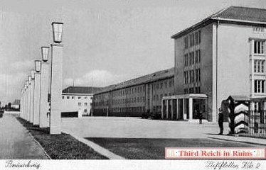
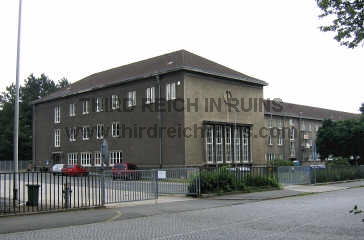
| A
Luftflottenkommando or headquarters for Luftwaffe Gruppe II was built in
Braunschweig in 1937-38. After the war the complex was used by the
British forces as Yorkshire Barracks, and is now a school and government
office building (Grünewaldstraße 16-20). (period postcard)
(Google Maps
link) |
|

|
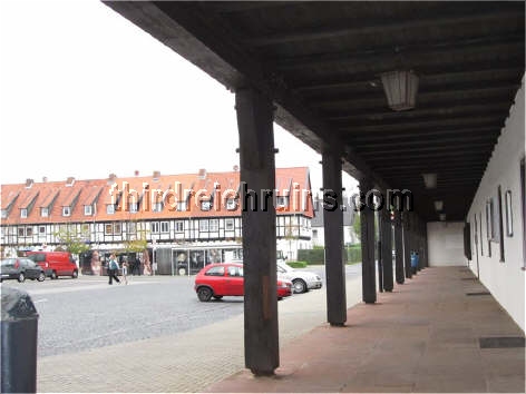
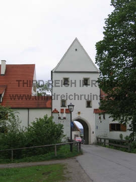
The
observation bunker was built overlooking a large open field that had
been used for SA (Sturm Abreilung - Storm Troopers - Brown
Shirts) rallies in the 1930s. The speakers platform for the SA rallies
still stands near the bunker on the Nußberg hill, overlooking the Franzsches Feld. |
|

|
|
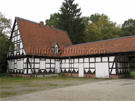
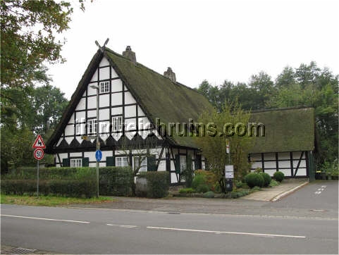
| The
gatehouse at the entry to the area (left) was built in the same style as
the main buildings. The guest house across the street is in an older
style with a thatched roof. |
|
|

|
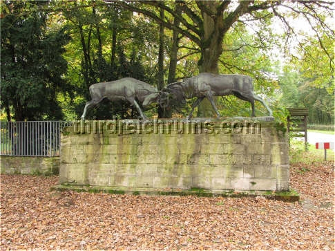
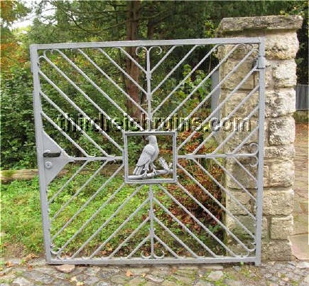
| The
entry area features a bronze sculpture of two battling stags by Johannes
(Hans) Darsow, and decorated iron fences and gates with stone gate
posts. |
 |
-
|

|

|

|
|
These three concrete air-raid
shelters were built in Fürth (near Nürnberg)
in 1943. The first, for 1072 people, is on Bei Korwinkel Straße; the
middle, for 788 people, is on Friedrich-Ebert-Straße; the last, for 901
people, is on Kronacher Straße. |
 |
 |
| This
grade school at Schwabacherstraße 86 in Fürth was decorated for a vote
in 1934. The building remains a school today. (Wikipedia
Bundesarchiv Collection) |
 |
 |
| An SA
school called the Waldlager was established in an existing building in
the Fürth Stadtwald (city forest), west of the city. This later became
an SS Sports School. The complex is now a private medical and housing
facility called the Waldkrankenhaus, and is not accessible to the
public. The view from Google Maps shows that it has been extensively
modified. (Google
Maps link) |
-
 |
 |
| A large
school complex to train students in the disciplines of finance and
revenue was built from 1935-39 in Herrsching am Ammersee. The school
featured several wings with living quarters, classrooms, kitchen and
dining rooms, a gymnasium, swimming pool, and air raid shelter. The
entry façade featured a large Reichsadler
Hoheitszeichen, one of the
best preserved examples today. The complex still serves as a school. |
 |
 |
| On the
left, a period aerial view of the Herrsching school complex. On the
right, a view of the wing seen in the center of the aerial photo. (Google
Maps link) |
-
 |
 |
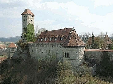
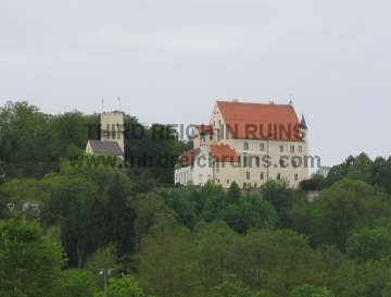
| Hermann
Göring's godfather owned Burg Veldenstein, at Neuhaus an der Pegnitz in
Franconia, and Göring lived there as a boy. Göring bought the castle
in 1939 and had it renovated, including an air-raid bunker in the lower
sections. However, he would not donate money for a swimming pool in the
town, saying, "If I can bathe my ass in the Pegnitz River, so can
the Neuhaus people." (photo
on left courtesy Ralf Hornberger) (Google
Maps link) |
 |
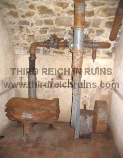 |
| Entry to
the Veldenstein air-raid bunker, with the normal bunker iron door, and
original ventilation equipment in the bunker. |
-
 |
 |
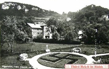
| This
1936-dated postcard view shows the Adolf Hitler Platz in Muggendorf, in
the Fränkische Schweiz ("Swiss Franconia") region of northern
Bavaria. The building in the background is the Rathaus (town
hall). (The large open area where the swastika was located is now a
childrens playground and a parking lot.) (Google
Maps link) |
-
|

|
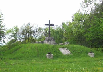
|
| This
unusual monument is located in the town of Hilpoltstein in Franconia. In 1934 the Nazis
erected this monument to the "National Uplifting" on the Solar
Hill, on a former solstice festival site, where a Hitler Oak and Hindenburg
Oak had been planted. After the war the monument was converted into a memorial to the victims of
Fascism. (Google
Maps link) |
-
 |
 |
| In the
summer of 1940 the Bavarian town of Grafenwöhr (adjacent to the famous military
training area) held a ceremony to welcome back the victorious
soldiers from the campaign in France. The sign on the Rathaus
above reads "Grafenwöhr grüßt die siegreichen Truppen"
(Grafenwöhr greets the richly victorious troops). (Google
Maps link) |
 |
 |
-
|
|
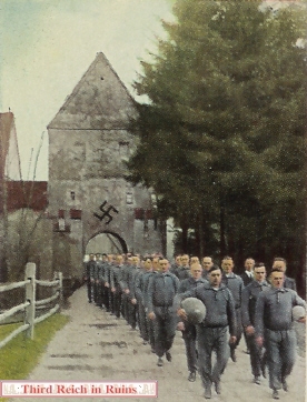
In 1933-34
the Frundsberg Castle in Mindelheim housed the Reichs Bauernschule, or
Farmers Academy.
The castle is open to the public.
(Google
Maps link) |
 |
 |
| Above,
the students leave the castle on their way to the exercise field. Below,
they raise a flag at one of several cannon positions around the castle
periphery. ("Der Staat der Arbeit und des Friedens,"
Altona-Bahrenfeld, 1934) |
 |
 |
 |
 |
| The
exercise field is now a parking area. Vegetation now obscures much of
the view of the castle in the background. |
-
 |
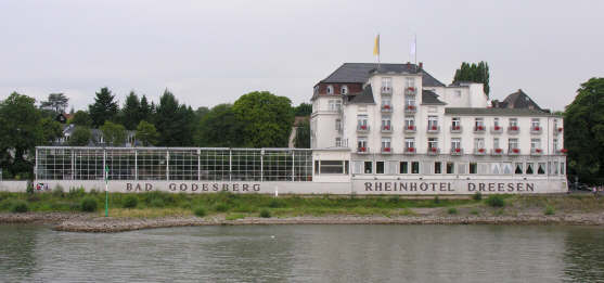
| The Rheinhotel
Dreesen on the Rhine River at Bad Godesberg (Bonn) hosted meetings between
Hitler and British Prime Minister Neville Chamberlain on 21-23 September
1938, regarding Hitler's proposed annexation of the Sudetenland
in Czechoslovakia. The hotel was also the site of Hitler's planning for
the purge of the SA (Sturm Abteilung) and its leader Ernst Röhm in June
1934. (Gerd Rühle, "Das Dritte Reich," Vol. VI,
1938; modern photo courtesy Robert Newton) (Google
Maps link) |
 |
 |
 |
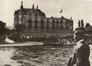
| Hitler
visits the Rheinhotel Dreesen. The hotel façade has been modernized
since 1938. ("Adolf Hitler" (1936); modern photo courtesy Robert
Newton; postcard views below from author's collection) |
 |
 |
 Proceed to Part
5
Proceed to Part
5
Go to the War
Memorials page
 Back to the Third Reich in Ruins homepage
|